By Callum Ludwig
The weather for Tuesday 13 February has prompted a call out to warn Victorians about fire risk conditions with heat, strong winds and dry thunderstorms predicted.
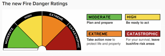
The Wimmera region has been classified as a catastrophic fire risk, extreme for Mallee and high fire risk for the rest of the state except for East Gippsland.
Emergency Management Commisioner Rick Nugent said we’re going to have an extremely hot, dry and windy day tomorrow across most of the state with up to 80-kilometre winds followed by thunderstorms and lightning.
“This is the first time since November 2019 we’ve had a catastrophic fire danger rating in this state. As a result, extensive planning and preparation has been undertaken by all agencies and departments in this state ahead of tomorrow’s conditions,” he said.
“We are doing everything possible to ensure we are well prepared to respond to any fires that may occur anywhere in the state. This includes strategically placing aircraft in the high-risk areas and being ready to respond whilst we’re doing everything we can do,”
“We also ask the community to ensure they are also doing what they need to do ahead of these catastrophic conditions and extreme conditions across the state to ensure that you activate your fire plan. Ensure that you leave and leave early if you are in a high-risk area of the fires.”
The morning is predicted to be sunny with a 60 per cent chance of showers, most likely in the afternoon and evening, as well as the chance of a thunderstorm at the same time. There will be northerly winds of 35 to 50 km/h before shifting south to southwesterly 25 to 35 km/h in the late afternoon.
Bureau of Meteorology’s Emergency Services Meteorologist Kevin Parkyn said he’s been in this game a number of years and it looks like these conditions are probably the worst he will have seen since the 2019/20 summer.
“We’re in a bit of a different situation, we’ve had recent rainfall in months, but conditions have changed in the last few weeks. We’ve had little if any, rain across much of the state, and that has certainly dried out grasslands,” he said.
“There’s a couple of other ingredients that we take into account, one of those is the thunderstorm risk. We’re expecting thunderstorms to develop during the afternoon and some of those storms could be severe, producing damaging wind gusts as they track very swiftly across the state from the northwest to the southeast,”
“The second component of a bad fire weather day is the wind change that we’re expecting tomorrow, it’s probably the strongest I have seen, or potentially I’ve seen for some years, as it sweeps across the southwest during the late morning.”
The winds are expected to move through the suburbs of Melbourne between 4pm and 6pm before making their way further east at night.
Country Fire Authority (CFA)’s Chief Officer Jason Heffernan said they’re calling on communities to be aware of conditions tomorrow and to take appropriate actions.
“Fires that start and take hold under catastrophic conditions can grow large very quickly, are dangerous and in fact, can be deadly and destroy property and communities,” he said.
“You must be up to date and remain up to date with information. The best way to do that is by downloading the VicEmergency app and having two sources of information, so also listening to your emergency broadcaster or keeping an eye on the VicEmergency website.”
You can download the VicEmergency app on the Google Play Store or App Store, monitor the VicEmergency website at emergency.vic.gov.au or find your local emergency broadcaster at emv.vic.gov.au/official-emergency-broadcasters-in-victoria.


